
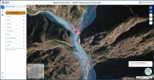
Mumbai, Sept. 7 -- to-use web-based platform integrates satellite imagery, open-source datasets and Suhora's own analysis into a single tool for tracking the disaster as it evolves.
As rescue and relief efforts continue across flood-affected districts in Nepal, Suhora Technologies, an Indian space-data analytics and intelligence firm, has launched a free, web-based disaster assessment platform to support ongoing relief and rescue operations. This builds on the satellite analysis the Noida-based company shared within hours of the devastation in Nepal's Betrawati and Trishuli region caused by the August 26 flash floods.
The disaster has claimed over 1,300 lives, with around 5,000 people, including foreign nationals, still unaccounted for. Suhora's analysis now spans nearly all major flood-affected districts, including Betrawati, Bidur, Devi Ghat, Mailung, Rasuwa, Syafru, Taruka, Timure, Trishuli Solar Plant and Trishuli Bazar.
The platform, accessible at www.nepalflood.suhora.com, brings together satellite imagery, open-source datasets and Suhora's own analysis into a single tool for tracking the disaster as it evolves. It analyses and provides data on buildings, bridges, roads, flood damage, barrier lakes and the source of glacial collapse.
Krishanu Acharya, Founder and CEO of Suhora Technologies, said the platform was developed to make satellite intelligence freely available during a crisis of this scale. "With ground access to several affected areas still severely disrupted, satellite data has become one of the few reliable ways to understand the scale of destruction and guide relief efforts to where they are needed most," he said. "We built this platform because we believe satellite intelligence should not sit behind closed doors during a crisis of this scale."
The platform is open to the public, including relief agencies, researchers, media and affected communities, and includes a feedback mechanism to help the Suhora team refine the tool as the response effort continues. Users can explore different layers, imagery, comparison tools and assessment data. It currently offers three core functionalities: an overview of major disaster-affected areas layered with open-source datasets and Suhora's analysis; visualisation and comparison of pre- and post-disaster imagery from ISRO, Vantor, PlanetScope, Sentinel and Landsat; and summary statistics and visualisation of affected buildings, bridges and flood-damage extent.
This follows Suhora's earlier satellite analysis of the Betrawati region, which found the area's commercial core buried under debris and identified a newly formed glacial lake spanning approximately 20.25 hectares at the source of the avalanche, raising concerns about further downstream flooding
Published by HT Digital Content Services with permission from Infrastructure Today.