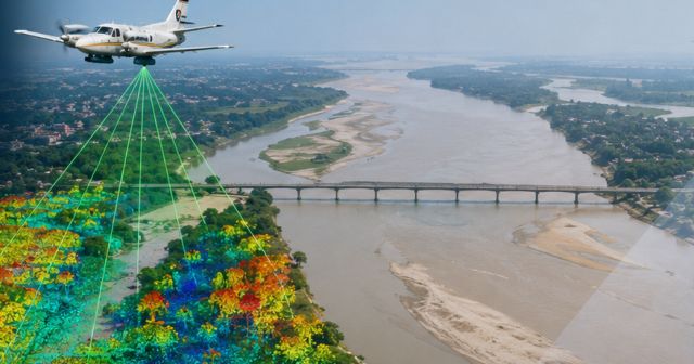
New Delhi, May 14 -- Geospatial technology firm Genesys International has secured a project from the National Mission for Clean Ganga to conduct aerial LiDAR surveys and geotagged videography of the River Ganga drainage system across four states, underscoring the growing use of geospatial intelligence in environmental and infrastructure planning, the company said on Thursday.
The project will span the Ballia-to-Farakka river stretch and cover parts of Uttar Pradesh, Bihar, Jharkhand and West Bengal. The assignment is expected to deploy a mix of manned aircraft and unmanned aerial vehicles (UAVs) to capture high-resolution geospatial datasets across the river corridor and associated drainage networks.
The move comes as government agencies increasingly turn to advanced mapping technologies and digital twins for large-scale environmental monitoring, urban planning and infrastructure management. LiDAR-based mapping, which enables high-precision terrain modelling and three-dimensional imaging, is gaining traction for applications ranging from flood-risk analysis to transportation planning and smart city projects.
According to the company, the project aims to create geospatial datasets that can support river-corridor assessment, drainage identification, terrain analysis and planning activities. The scope includes aerial LiDAR surveys, photogrammetry, orthorectified imagery and geotagged videography of both natural and manmade drainage systems feeding into the river.
The deliverables are expected to include 3D LiDAR point-cloud datasets, geotagged drainage information, annotated aerial video and high-resolution orthorectified imagery that could support multiple planning and environmental use cases.
Industry experts say detailed geospatial mapping is becoming increasingly critical as policymakers seek better visibility into river ecosystems and associated environmental risks. Such datasets can help authorities identify pollution sources, monitor drainage networks and support interventions related to wastewater treatment and floodplain management.
Sajid Malik said the project demonstrates the use of integrated manned and unmanned aerial technologies for large-scale river intelligence initiatives.
"We believe this is an important emerging geospatial vertical, with the potential to support environmental restoration, wastewater planning, floodplain management and multiple development use cases across India's river systems," Malik said.
The company said the datasets generated through the initiative could support future applications including drain and confluence mapping, pollution hotspot identification, wastewater interception planning and river-edge infrastructure development.
Published by HT Digital Content Services with permission from TechCircle.